
App aims to help Palestinian drivers find their way around checkpoints
Doroob Navigator goes beyond other apps’ traffic algorithms, guiding West Bank motorists past Israeli restrictions and helping them avoid long lines
")
A new Palestinian-made mobile driving app seeks to fill the gaps left by mainstream platforms like Google Maps and Waze in navigating the restrictions faced by Palestinian drivers in the West Bank.
The app, Doroob Navigator, is the brainchild of tech entrepreneur Mohammad Abdel Haleem, who told Reuters in a Monday report that he discovered the need for a map specifically tailored to Palestinians when Google Maps sent his car into a distant valley as he attempted to navigate from Bethlehem, just south of Jerusalem, to Ramallah, a short drive northward.
“We had to design our maps completely from scratch. The wall, checkpoints, settlements…. Existing mapping software could never account for the complexity here,” the 39-year-old told Reuters.
Launched in June, the app already boasts 22,000 users. Doroob Technologies, which develops the navigation software, is funded by Ramallah-based software firm Ideal, also controlled by Abdel Haleem.
As with Waze and Google Maps, the app lets users report traffic trouble, but in Doroob’s case they include pop-up Israeli police and military checkpoints or road closures, creating a more precise picture of the traffic reality for Palestinian drivers.
Google Maps does not distinguish between Israeli and Palestinian drivers or Israeli-controlled and Palestinian-controlled areas when offering traffic suggestions.
The Israeli-made Waze allows users to check a box allowing or forbidding their entry into Palestinian population centers. The feature reflects the fact that while Israelis are largely forbidden from entering Palestinian towns, Arab Israelis often do so to visit family or conduct business.
Yet, neither app has a similar function focused on Palestinians that maps Israeli restrictions and helps them navigate more easily between major West Bank destinations.
For example, Palestinian-licensed vehicles usually cannot drive freely through Israeli settlements, though algorithms of mainstream apps sometimes suggest doing so to cut travel time.
Besides the user-generated information, Doroob’s staff is manually teaching the app to guide drivers around such settlement roads.
“Other apps might say the only way to drive between certain Palestinian cities is to cut through a settlement,” Abdel Haleem told Reuters. “We’re trying to change that.”
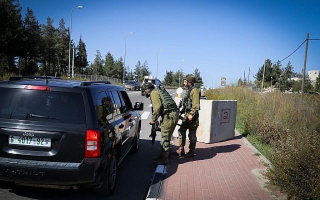
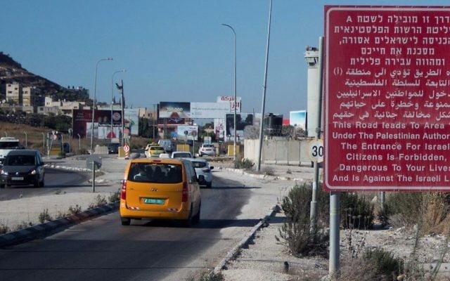
Israel has constructed a system of bypass roads that allow Israeli motorists to travel up and down the West Bank without entering Palestinian cities, and the same roads are used by Palestinians daily. But cars with Palestinian license plates are often stopped for inspections at some checkpoints, particularly surrounding Jerusalem, and roadblocks leading out of Palestinian areas regularly produce very long traffic jams due to Israeli security measures.
Israel took control of the West Bank after conquering the territory in the 1967 Six Day War. Palestinians and most of the international community accuses Israel of illegally settling the area and restricting the rights of Palestinians living there. Israel contests the claim that settlements are illegal and says the checkpoints and security barriers established in the West Bank have been key to suppressing massive waves of suicide bombings and other terror attacks over the years.
Abdel Haleem said the app also works in Gaza, though Israel left the enclave in 2005 and no Israeli restrictions are in place there. Most users, he said, are in the West Bank. He said he plans to integrate a delivery service into the app that will help monetize it in the future.


")
")
")
")
")
")
")
")
The Times of Israel Community.