

Live Update  From the Liveblog of
Monday, July 28, 2014
From the Liveblog of
Monday, July 28, 2014
From the Liveblog of
Monday, July 28, 2014
UN imagery shows Shejaiya damage
 Add ToI as a Preferred Source on Google
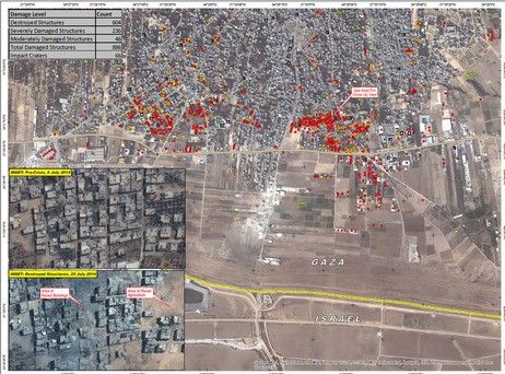
The United Nations publishes satellite imagery showing the Shejaiya neighborhood before and after intense ground battles and airstrikes there.
Called “Damage Assessment in Northeastern Gaza Strip – Occupied Palestinian Territory,” the images, published Saturday by the UN’s Operational Satellite Applications Program, shows two localized zones of intense damage in the neighborhood, in which structures were completely destroyed, with the rest of Shejaiya relatively intact save for scattered damaged and ruined buildings.
According to the document, the UN claims to have identified 886 damaged structures, including 604 which were completely destroyed.









If you’d like to comment, join
The Times of Israel Community.
The Times of Israel Community.
JOIN THE TOI COMMUNITY
Already a member? Log in here